
Fájl:1744 Wren Map of London, England - Geographicus - London-wren-1744.jpg
Az előnézet mérete: 800 × 559 képpont További felbontások: 320 × 224 képpont | 640 × 447 képpont | 1 024 × 716 képpont | 1 280 × 895 képpont | 2 560 × 1 790 képpont | 5 000 × 3 496 képpont.
Eredeti fájl (5 000 × 3 496 képpont, fájlméret: 4,43 MB, MIME-típus: image/jpeg)
|
Ez a fájl a Wikimedia Commonsból származik. Az alább látható leírás az ottani dokumentációjának másolata. A Commons projekt szabad licencű kép- és multimédiatár. Segíts te is az építésében! |
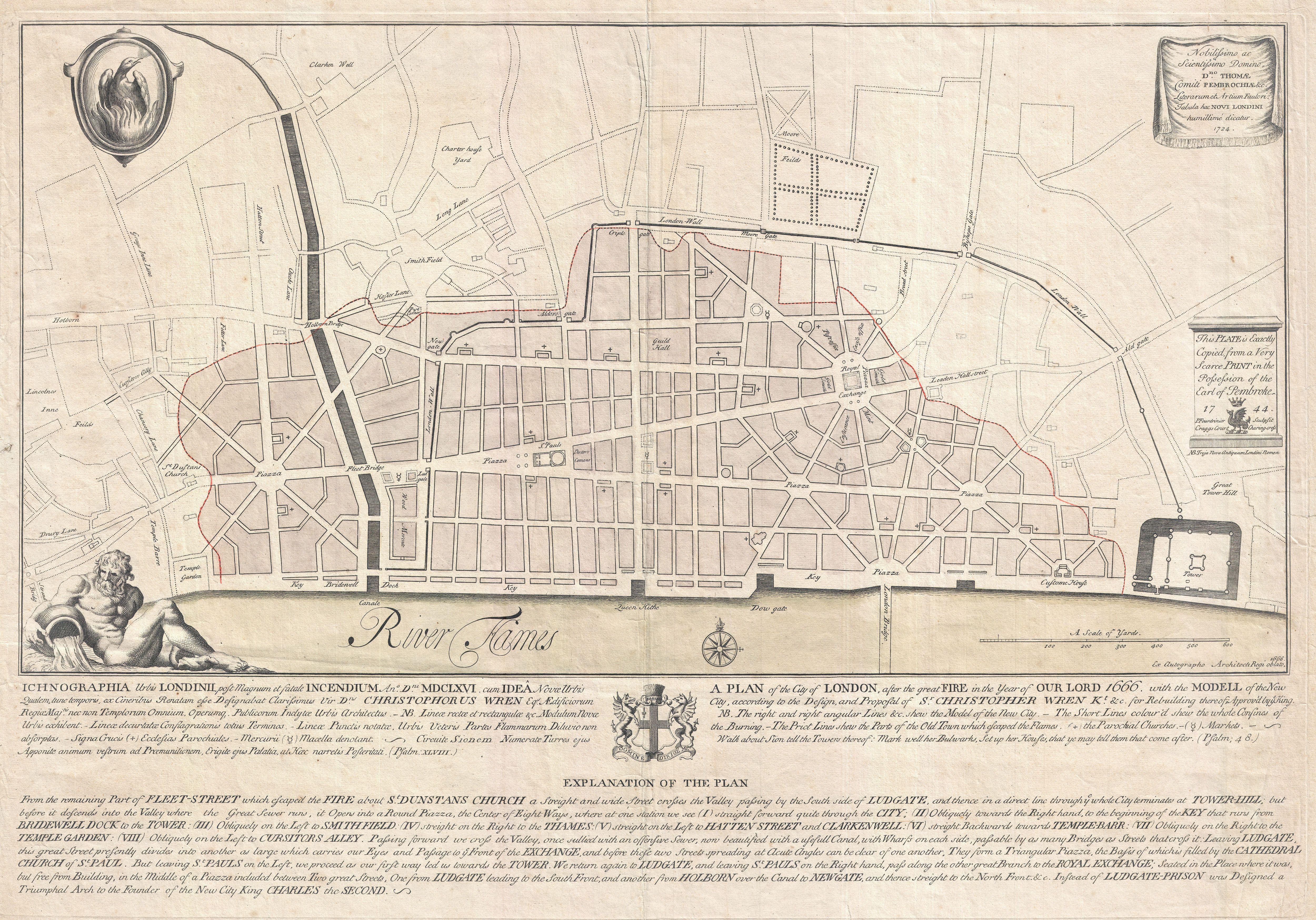
| Christopher Wren: Ichnographia urbis Londinii… (A Plan of the City of London, after the great FIRE, in the Year of Our Lord 1666.)
( |
|||||||||||||||||||||||||||
|---|---|---|---|---|---|---|---|---|---|---|---|---|---|---|---|---|---|---|---|---|---|---|---|---|---|---|---|
| Művész |
|
||||||||||||||||||||||||||
| Mű címe |
Ichnographia urbis Londinii… (A Plan of the City of London, after the great FIRE, in the Year of Our Lord 1666.) |
||||||||||||||||||||||||||
| Leírás |
English: An extremely scarce 1744 map of London showing Sir Christopher Wren's plan for reconstructing the city following the 1666 Great Fire of London. In 1666 the Great Fire swept through the old Roman portions of London, laying waste to most of the original walled city. Christopher Wren, a well known architect of the period was quick to respond to the disaster as a opportunity to dramatically redesign and modernize London's center. Wren having been schooled in Paris envisioned an elaborate classically influenced reconstruction of the city with broad avenues meeting in a series of Piazzas. Despite, or perhaps because of, Wren's promptitude in producing a plan for a major post-fire reconstruction, his plan exhibits a number of dramatic errors. Wren did not take the city's topography into account and consequently much of the this plan is unfeasible. Despite claims to the contrary in the document itself, Wren's plan was never seriously considered by either the King or the Parliament. Today Wren's original 1666 plan is lost. This version was drawn in 1744 by the once fashionable engrave P. Fourdrinier, who claims to have replicated exactly a scarce 1724 original owned by the Earl of Pembroke. This map covers London along the north side of the Thames River from Strand Bridge to Great Tower Hill. Shows Wren's detailed reconstruction plan, along with the regions originally destroyed by the Great Fire. Identifies the proposed locations of parochial churches, markets, piazzas, bridges and warehouses. A vignette in the lower left quadrant depicts Thamesis, the river god for which the Thames River is named. The upper left quadrant bears the image of a phoenix, suggesting that, like the mythical bird, London too would rise from its own ashes and be reborn in fire. The lower quadrants of this plate include the map's title in both English and Latin as well as a detailed Explanation of the Plan. This plan is highly uncommon and rarely appears outside of institutional collections. |
||||||||||||||||||||||||||
| Dátum | 1744 (dated) | ||||||||||||||||||||||||||
| Méretei | magasság: 19 hüvelyk (48,2 cm); szélesség: 27,5 hüvelyk (69,8 cm) | ||||||||||||||||||||||||||
| Leltári szám |
Geographicus link: London-wren-1744 |
||||||||||||||||||||||||||
| Forrás/fényképész |
|
||||||||||||||||||||||||||
| Engedély (Fájl újrafelhasználása) |
|
||||||||||||||||||||||||||

Fájltörténet
Kattints egy időpontra, hogy a fájl akkori állapotát láthasd.
| Dátum/idő | Bélyegkép | Felbontás | Feltöltő | Megjegyzés | |
|---|---|---|---|---|---|
| aktuális | 2011. március 23., 22:42 | | 5 000 × 3 496 (4,43 MB) | BotMultichillT | {{subst:User:Multichill/Geographicus |link=http://www.geographicus.com/P/AntiqueMap/London-wren-1744 |product_name=1744 Wren Map of London, England |map_title=Ichnographia urbis Londinii… (A Plan of the City of London, after the great FIRE, in the Year |
Fájlhasználat
Az alábbi lap használja ezt a fájlt:
Globális fájlhasználat
A következő wikik használják ezt a fájlt:
- Használata itt: ar.wikipedia.org
- Használata itt: az.wikipedia.org
- Használata itt: en.wikipedia.org
- Használata itt: es.wikipedia.org
- Használata itt: fr.wikipedia.org
- Használata itt: id.wikipedia.org
- Használata itt: ka.wikipedia.org
- Használata itt: ko.wikipedia.org
- Használata itt: nl.wikipedia.org
- Használata itt: pl.wikipedia.org
- Használata itt: pt.wikipedia.org
- Használata itt: ru.wikipedia.org